Drawing the Natural Gardens of North Carolina
Betty Lou Chaika
Report for Certificate in Native Plant Studies, North Carolina Botanical Garden, Chapel Hill
October, 2013. Advisor: Steph Jeffries
Abstract The Drawing the Natural Gardens project was initiated to bridge between the Botanical Illustration and Native Plant Studies programs by combining drawing and ecology. The goals of the project were a) to show the possibilities of nature journaling or field sketching for getting to know plant communities, plant/animal interactions among species, and plant interactions with their environments; b) to introduce others to the wonderful beauty and diversity of our North Carolina natural gardens and generate interest in saving what we have left.
The project included visiting and drawing many of our North Carolina habitats in Mountains, Piedmont, and Coastal Plain and creating visual/verbal narratives of seasonal ecological observations, recording a slice of place at a point in time. Each drawing is an overview of a particular community on a particular day in a particular season, as observed in the field. This report contains scans of most of the sketchbook’s double-page spreads, which show how the drawings evolved from field sketches to studio-completed drawings, and includes some supplementary information about these habitats.
For those of us who live here, North Carolina is our homeland. It is our special Place. Within the vast landscape of this beautiful state there are a wonderful variety of different natural habitats. Each habitat, with its unique combination of elements (elevation, topography, types of rock and soil, temperature, moisture) is home to special groupings of plants and animals. B.W. Wells, botanist, avid conservationist and pioneer North Carolina ecologist, wrote a book about these communities called The Natural Gardens of North Carolina. Use of this title is meant to honor his work.
For this project I went on what I regarded as little ecological pilgrimages to special habitats and drew about twenty of these wonderful places. For the most part I went on these fieldtrips with groups of people, mostly from the NC Museum of Natural Sciences and the NC Native Plant Society, some of whom knew insects, reptiles, birds, and geology as well as plants. These started out as field sketches in the moment as we walked, but then became additionally researched habitat drawings completed in the studio. Here are scans of the sketchbook’s double-page spreads that show the progression of my work and how the drawings evolved. What I discovered was that the compositions emerged in such a way that it seemed like the places drew themselves and told their own stories. Included in this report are most of the spreads and some supplementary information about the habitats.
Artwork copyright © 2013 by Betty Lou Chaika. No images may be copied, displayed, reposted, or republished without express consent of the artist.
Mountains: Dupont State Forest, Little River
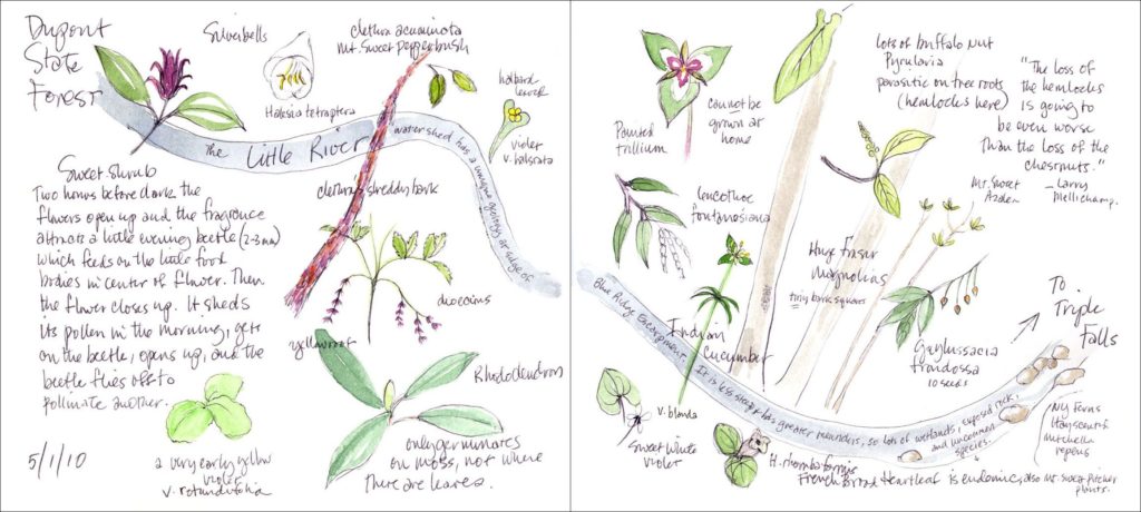
5/1/10 Dupont State Forest, Little River
We walked along the Little River in Dupont State Forest. The Little River watershed has a unique geology at the edge of Blue Ridge Escarpment. It is less steep and has greater meanders, so there are lots of wetlands, exposed rock, and uncommon species.
Mountains: Dupont State Forest, Waterfalls Along the Little River
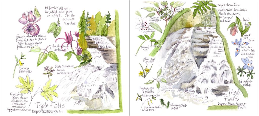
5/1/10 Dupont State Forest, Waterfalls Along the Little River
There are a number of waterfalls along the Little River. Triple Falls is on the left. Climbing ferns occur all across the state, but are very uncommon. Beyond the falls we saw a huge patch of them. Plant communities around High Falls are on the right.
Mountains: Dupont State Forest, Cedar Rock Mountain
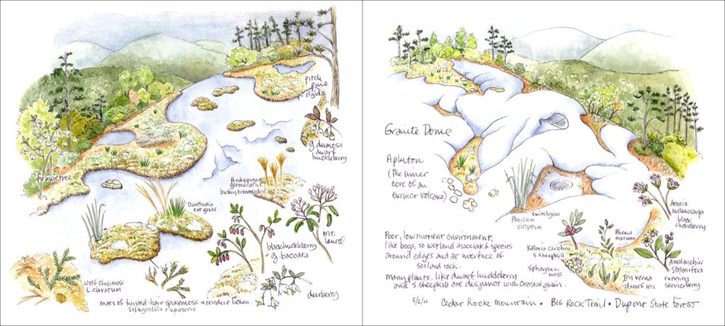
5/2/10 Dupont State Forest, Cedar Rock Mountain
What a magical place! This is a low-elevation granite dome or pluton, the inner core of an extinct volcano. Because these formed deep underground, they have no joints to erode, so have no cracks in which plants can grow. A process called exfoliation causes thin layers of rock to shear off, leaving smooth, rounded, surfaces. Vegetation gains a foothold wherever it can.1
The drawing on the left shows how plants (twisted-hair spikemoss, reindeer lichen, grasses) have taken root in mats of soil on the smooth rock. Along the edges there are a variety of plants characteristic of exposed, dry areas, like vacciniums, pitch pines and fringe trees. In other places on the rock there are depressions in the granite filled with vegetation. The drawing on the right shows plants growing in these depressions. This is a poor, low-nutrient environment, like bogs are, so there are wetland-associated species around the edges and at the interface of soil and rock. Many plants, like dwarf huckleberry and southern sheepkill are disjunct with the Coastal Plain.
Coastal Plain: Holly Shelter Gamelands
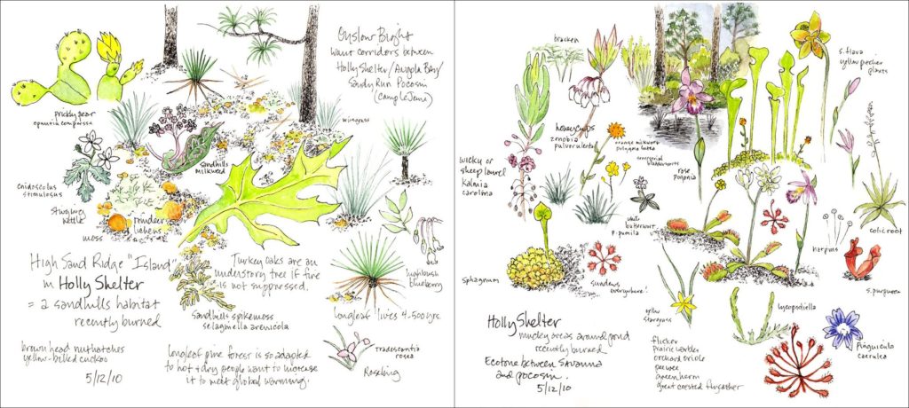
5/12/10 Holly Shelter Gamelands
Holly Shelter, 75,000 acres, is a vast wilderness of longleaf pine savannas, pine flatwoods, pocosins, swamps and wetlands interspersed by sand ridges, on the Onslow Bight. A “bight” is a long, gradual curve in a shoreline, in this case from Cape Lookout to Cape Fear. Conservation groups, including The Nature Conservancy (TNC), are trying to conserve habitat corridors between the large protected areas of Holly Shelter, Angola Bay Gameland, and Sandy Run Pocosin in Camp Lejeune and promote appropriate land management including the use of fire.
The drawing on the left shows a high sand ridge “island,” a sandhills-like habitat of longleaf and turkey oaks, recently burned. On the right are carnivorous plants. These are plants of the mucky areas around borrow ponds (depressions dug out for soil to construct tracks), recently burned, in the ecotone between long leaf savanna (grasslands) and pocosin (evergreen shrub bogs).
Mountains: Moses Cone Park
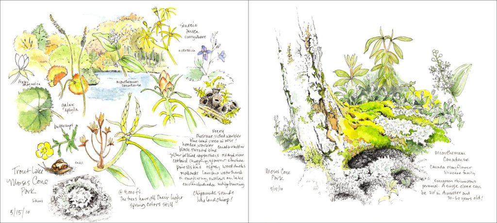
5/15/10 Moses Cone Park
Moses H. Cone Memorial Park, near Blowing Rock on the Blue Ridge Parkway, preserves the 3,500-acre country estate of Moses Cone, a prosperous textile entrepreneur (think denim), conservationist, and philanthropist. Moses Cone’s interest in conservation led him to plant white pine forests and hemlocks and build several lakes stocked with fish. In 1907, when the forested mountains had nearly been denuded, Moses Cone and others helped to get a bill through Congress to form the Appalachian Forest Reserve and to buy forests from willing sellers to protect them. This forestland became part of the Pisgah National Forest.
On the left are plants around Trout Lake. At 4,000 feet the trees still have all their light spring colors. The image on the right shows Canada mayflower, which was an exciting plant to see there. Mianthemum canadense, lily family, is an evergreen rhizomatous perennial, more common in the north. A single clone can be 20’ in diameter and 30-60 years old! It is quite fragrant.
Mountains: Rich Mountain Gap Road, Amphibolite Range
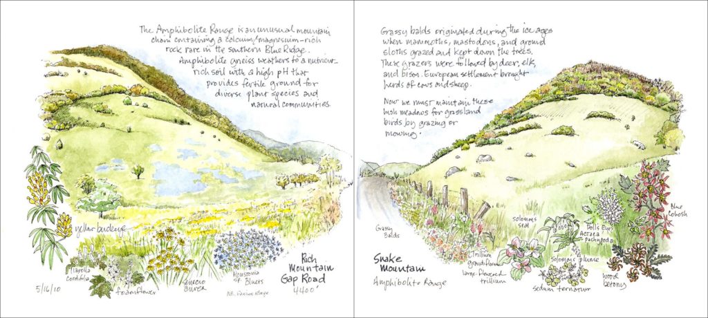
5/16/10 Rich Mountain Gap Road, Amphibolite Range
Rich Mountain Gap Road is at 4,400 feet in the Amphibolite Range, which is north of Boone. The New River’s headwaters spring from the Amphibolite Mountains. The Amphibolite Range is a unique mountain chain containing a calcium/magnesium-rich rock, which is otherwise rare in the southern Blue Ridge. Amphibolite gneiss is a rock that weathers to a nutrient-rich soil with a high pH, a fertile soil that supports diverse natural communities. “The Nature Conservancy and its partners are working to create an expansive wilderness area in the amphibolite range by linking existing conservation lands at Bluff, Three Top, Elk Knob and Mount Jefferson.” [TNC] With the recent purchase of Phoenix Mountain, all the amphibolite peaks in the New River Headwaters are now protected.
The drawing on the left shows Rich Mountain, parts of which are protected as well. The Amphibolites average about 5,000 feet. The drawing on the right shows Snake Mountain, the highest, at 5,566 feet. Grassy balds such as these were possibly maintained by a “chain of herbivores.” First, by Pleistocene megaherbivores (mammoths, mastodons, ground sloths), then less successfully through grazing by modern herbivores (deer, elk, bison), and then even less successfully by colonial livestock (horses, cows, sheep, goats) as well as by natural and human-ignited fire. Over time these grassy balds have shrunken. Now either grazing or mowing must be utilized to preserve this natural meadow community of grasses, sedges and wildflowers. This early successional grassy habitat must be maintained for grassland birds, like golden-winged warblers, eastern meadowlarks, and bobolinks that are disappearing, as habitat is lost. 2
The diversity of wildflowers in these nutrient-rich habitats is wonderful!
Piedmont: Haw River State Natural Area
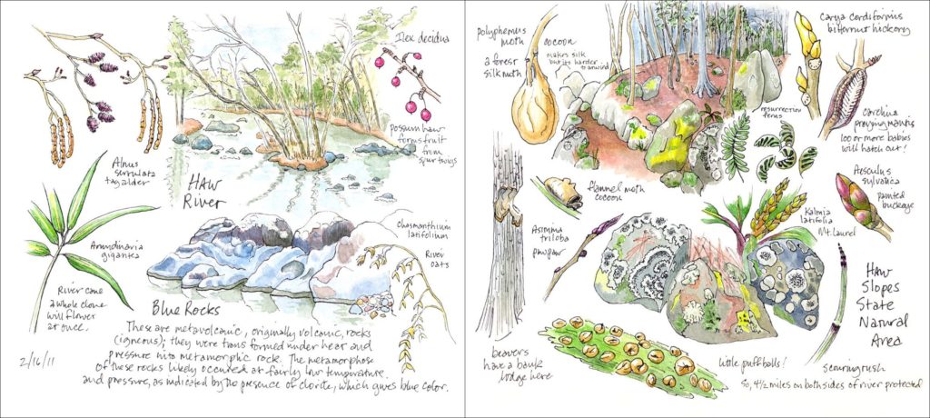
2/16/11 Haw River State Natural Area
The Haw River originates above Greensboro and flows for 100 miles before converging with the Deep River and then the Cape Fear. The protected area runs for 41/2 miles along both sides of the Haw from Bynum south to below US 64. It meets up with already-protected Jordan Lake lands.
The drawing on the left shows the wonderful blue rocks in the river. These are volcanic rocks; they were transformed under heat and pressure into metamorphic rock. But this likely occurred at fairly low temperature and pressure, as indicated by the presence of chlorite, which gives the rocks their blue color. Along the bank here are a lot of river oats and river cane (A. gigantea). In the Piedmont there are two species of cane, A. gigantea (20 ft.) and the smaller A. tecta (10 ft.), also of the Coastal Plain. This is a new trail and there was very little evidence of microstegium. Perhaps if the leaf litter were to remain intact, river oats might outcompete microstegium. The drawing on the right shows the Haw slopes. There was a noticeable presence of evergreens at the wonderful rock outcrops: mountain laurel, red cedar, and short leaf pine as well as holly and sparkleberry. The stars of the show were all the colorful lichens.
Piedmont: Raven Rock State Park

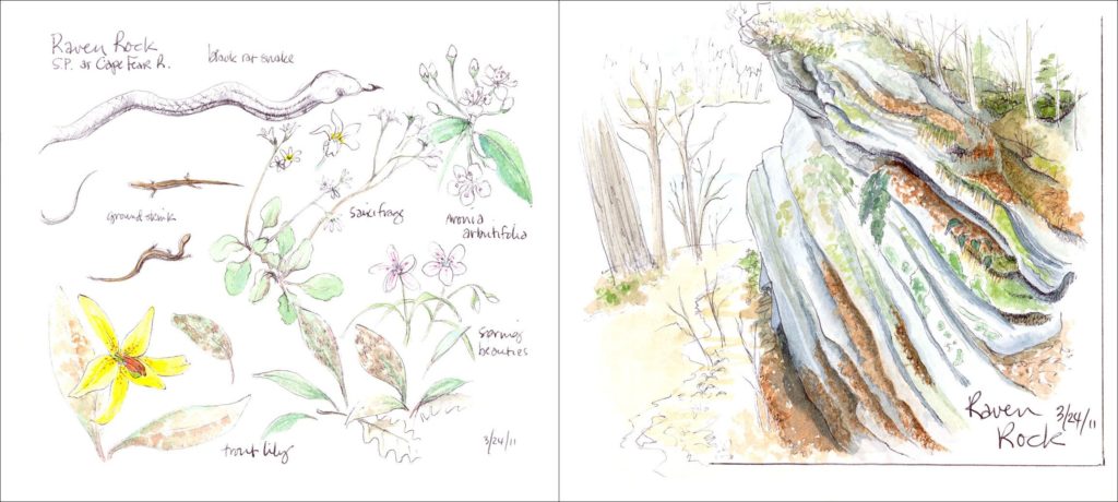
3/24/11 Raven Rock State Park
Raven Rock State Park is on Cape Fear River, south of Sanford. “The plant communities and wildlife of the park are generally typical of maturing, successional habitats of the eastern Piedmont. Pines and mixed hardwoods dominate the bluff top, and mature beech and mixed alluvial hardwoods cover the slopes and floodplain. One hundred and sixty bird species have been observed in the park.” 3
The first spread shows Raven Rock Park’s upper forest on the left and the lower, creek forest on the right. The second spread on the left shows reptiles nearer the river and floodplain plants. Raven Rock is on the right. Raven Rock cliff is a steep quartzite bluff, 150 feet, which is high for the eastern Piedmont, formed by undercutting from the flow of the river. These are the highest bluffs in the North Carolina fall zone where the harder, resistant rocks of the Piedmont meet the softer sediments of the Coastal Plain.
Piedmont: Swift Creek Bluffs

4/9/11 Swift Creek Bluffs
Swift Creek Bluffs is a Triangle Land Conservancy (TLC) preserve in Cary. It is comprised of several wonderful ecosystems. The first spread shows on the left the swamp forest ecosystem with a depression swamp with overcup oak at the base of the bluffs. The right side shows the levee forest along the creek and describes the bottomland hardwood forest of the alluvial flats. The third drawing represents the slopes of the upland bluffs community, a basic, mesic forest with its huge beeches. At the top of the bluff, the upland forest is a drier oak-hickory forest.
Piedmont: B.W. Wells’ Rockcliff Farm
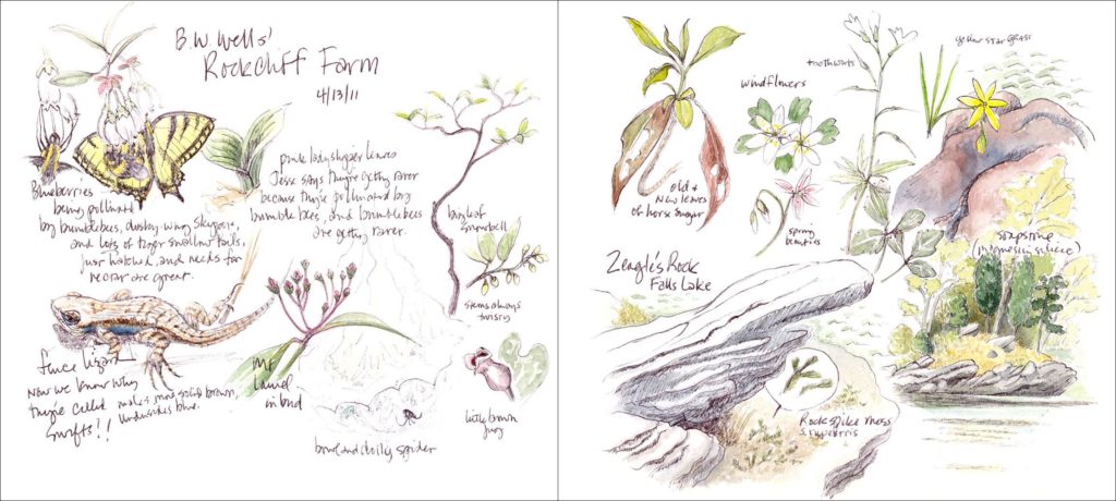
4/13/11 B.W. Wells’ Rockcliff Farm
B.W. Wells was a pioneer North Carolina ecologist and a passionate conservationist. He and his wife moved in retirement to this 154-acre farm in 1954 and named it Rockcliff Farm because of its unique geology and wildflowers. In 1983 the Neuse River was dammed, creating Falls Lake, which flooded about half of the farm, which is now a mixture of early successional and mature forest. There are six miles of trails. The B.W. Wells Association will be doing some burning and hopes that more of the original wildflowers will re-emerge. The drawing on the left shows some encounters along the trail. On the right shows what’s left of once-high Zeagle’s Rock, with the rise of Falls Lake.
Piedmont: Flower Hill Rhododendron Bluffs
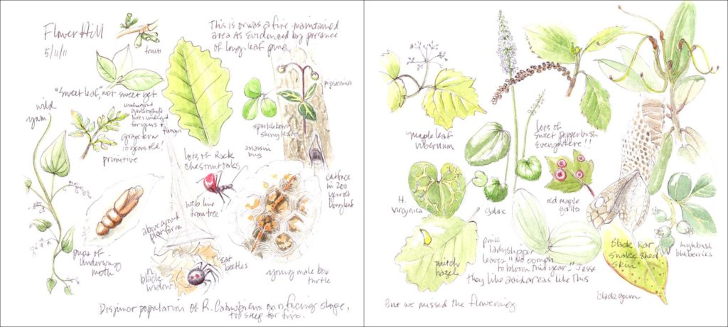
5/11/11 Flower Hill Rhododendron Bluffs
This is a 10-acre TLC preserve in Johnston County, open to the public. It was actually identified as special by B.W. Wells. Composed of steep north-facing erosion-resistant bluffs above Moccasin Creek, it maintains a moderate microhabitat for chestnut oak, witch hazel, rhododendrons, galax, trailing arbutus and other mountain plants. In the left-hand drawing are some of the plants along the trail. This was a fire-maintained area as evidenced by the presence of this cat-faced long leaf pine. This is the eastern-most population of Rhododendron catawbiense, disjunct from the Mountains. The drawing on the right was to show the blooming rhododendrons, but we missed the flowering!
Piedmont: Picture Creek Diabase Glade
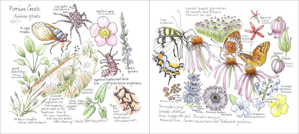
6/8/11 Picture Creek Diabase Glade
This is a remnant “Piedmont prairie,” near Butner. Under power lines, it has been maintained by periodic mowing, which mimics fire. Now a fire regimen has been started. The drawing on the left shows one of the little wet ecosystems found there. The Triassic basin is underlaid with basalt, a diabase rock that is higher in magnesium and calcium. This rock weathers to soils with a high “shrink-swell” clay that swells in the presence of water, then shrinks and cracks as conditions dry. Temporary pools of water are held in any mud ruts. These form whole little ecosystems and provide breeding places for a number of species of amphibians, which must eat, grow, transform, and hop out before the water dries up!
On the right are smooth coneflowers. The underlying basalt rock weathers to a higher pH soil. Here is the world’s largest population of smooth coneflowers, Echinacea laevigata. Marshallia legrandii, tall Barbara’s-buttons, is a beautiful newly described species. It is found in diabase bedrock with shrink-swell clay soils primarily in remnants of a few fire-maintained “prairies.”
Shaken Creek Savanna Preserve
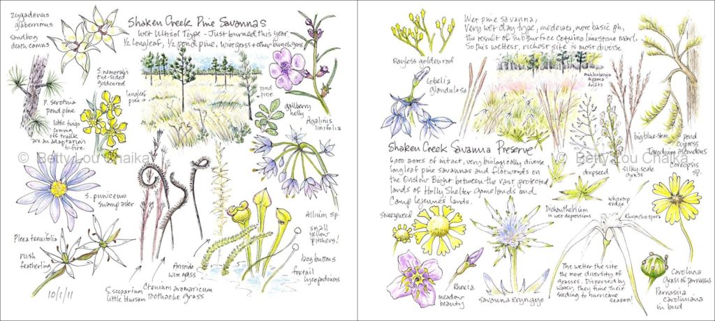
10/1/11 Shaken Creek Savanna Preserve
Conserved by TNC, this preserve, 6,000 acres, is also on the Onslow Bight, the vital corridor linking the 150,000 acres of Camp Lejeune with the 100,000 acres of Angola Bay and Holly Shelter. Geologically it lies on the Cape Fear Arch, a plateau of land that is a few feet higher than the rest of the Coastal Plain. It has been above sea level for a longer period, therefore Shaken Creek has an older history and distinctive soil qualities that allow it to harbor extremely rare natural communities. Since it’s never been plowed, it maintains a very high biological diversity. It is reportedly one of the few places in North Carolina that remain in a condition similar to that encountered by the first Europeans and is one of the best natural areas existing today on the entire Atlantic seaboard. [TNC]
This sketchbook spread shows pine savannas, which are the wettest of the longleaf pine communities. Shaken Creek is the only known site in North Carolina with all four types of the Outer Coastal Plain Pine Savanna natural communities. These grassy openings occur in flat, poorly drained areas where fire is frequent, shrubs and hardwoods are suppressed, and the appearance is open and parklike. The ground between the scattered pines is generally covered by a savanna composed of dropseed grass (Sporabola) in the wetter areas, wiregerass (Aristida) in the drier savanna, and a natural garden of flowers, including orchids, lilies, goldenrods, sunflowers, asters, pitcher plants, and Venus’ fly-traps. They are ringed by longleaf and pond pine forests that provide habitat for red-cockaded woodpeckers, migrant songbirds and black bears. [TNC] The drawing on the left shows the Wet Ultisol Type. On the right is the Very Wet Clay type of pine community surrounded by pond cypresses. I think this is now referred to as Very Wet Loamy type. The beauty of the fall seeding grasses and wildflowers is glorious.
Coastal Plain: Croatan National Forest, Island Creek Trail
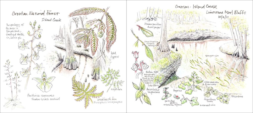
10/2/11 Croatan National Forest, Island Creek Trail
The geology of the area is compacted, fossilized shells, coquina limestone, so it has a more basic pH soil. We were interested in this population of 30 or so shadow witch orchids, Ponthieva racemosa, an uncommon species. The drawing on the right shows limestone marl bluffs. “Along Island Creek, exposures of limestone and more basic soil than is found in most of the Coastal Plain have created a habitat for a variety of alluvial and swamp hardwood communities and rare species. Island Creek is a blackwater tributary to the Trent River. On the creek banks are numerous limestone outcrops composed of fossilized shells.”4
Coastal Plain: Black River Paddletrip
10/8/11 Black River Paddletrip
The Black River is a major tributary of the Cape Fear. Here’s a good description of Coastal Plain blackwater: “Blackwater rivers and streams are those that originate in the flatlands and sandy soils of the Coastal Plain. If you have seen one of these rivers, you don’t have to ask why we call them blackwater. Look into deep water and you see only mysterious darkness. The well-known explanation is that the water is stained with tannins, leached from dead plant material in the swamps. But this is only half of the story. Equally important is what isn’t in the water: the suspended clay and silt that are common in Piedmont rivers and in Coastal Plain brownwater rivers. The water is transparent instead of being turbid, and light disappears into its depths rather than being scattered back to the surface. If you look at shallow water with the sun shining through it to a sandy bed, it is clear red-brown, like tea. The absence of silt and clay is important ecologically. Most river floodplains have very fertile soils because nutrients are deposited by the river with these sediments. But blackwater is acidic and poor in nutrients, and the soils along these rivers are generally sterile sand or organic muck. This affects what kinds of plants can live in the floodplain. The water is also low in oxygen, which limits which fish, mussels and aquatic insects make up the aquatic community of the river. Both the floodplain community and the aquatic community have relatively few species compared to the communities of other kinds of rivers.” 5 Plant and tree detritus provides the fuel for the aquatic ecosystems in the river.
The drawing on the left shows a bank beaver lodge. Where water levels vary too much for a lodge, beavers burrow into a bank. On the right are cypress trees in the Black River Preserve. Some exceeding 1,600 years old, they are the oldest stand of trees in eastern North America. Cypress seedlings can only start on dry soil, so they need to germinate and get tall enough before flooding. Carolina parakeets, our only native parrots, now extinct, dispersed the seeds of bald cypress.
Piedmont: Mitchell Mill Flatrock State Natural Area
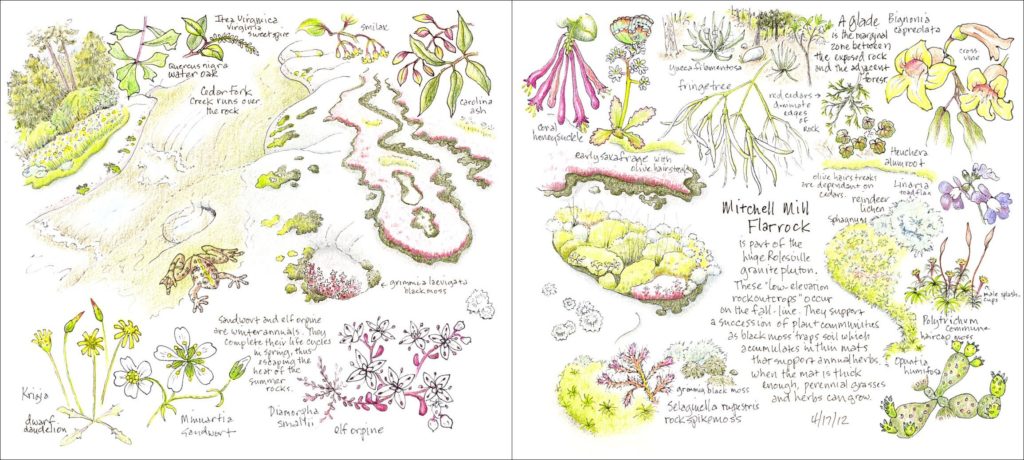
4/17/12 Mitchell Mill Flatrock State Natural Area
Mitchell Mill is 93 acres of granitic flatrock and associated woodlands. It is part of the Rolesville granite pluton, a tongue of granite bedrock 50 miles long and 10-12 miles wide. It stretches from Johnson County to the Virginia border, the largest of its kind in the eastern U.S. The Piedmont is flatter than the Mountains, so exfoliation of the granite produces flat expanses of rock called flatrock.
The left drawing shows Cedar Fork Creek, a tributary of the Little River, running over the flatrock and the red mats of flowering elf orpin, Diamorpha smallii, a winter annual. One of the pioneer plant species occurring in the depressions, Diamorpha smallii grows only on, is endemic to, fall-line granite outcrops. It is a rare plant in North Carolina. Granite flatrocks are sometimes called “nature’s rock gardens.”
Mitchell Mill Flatrock tells a wonderful primary succession story. For plants to grow on bare rock soil has to build up permitting water to be retained, and that can take many years. First, lichens secrete acid that breaks the rock into small grains and then they push anchoring threads into the rock. But, the actual soil trapping begins with black moss (Grimmia laevigata), also called resurrection moss because it turns from black to bright green and starts photosynthesizing when it receives only a tiny amount of water. Eventually, thin mats of soil accumulate and the small annual flowers, elf orpine and sandwort, as well as reindeer lichens and hair-cap moss can grow. In turn they trap more soil until a mat is thick enough to support perennials and grasses. These colorful, sometimes elegantly shaped, mats of flowers, grasses and mosses are very lovely set against the surface of smooth, bare gray rock.6
The right hand drawing shows some of the wetter edges where rock meets adjacent forest soils and the forest glade beyond. In the marginal zone between the exposed rock and the forest, where deeper, but still thin, soils have accumulated, an open and grassy glade of trees, shrubs and Yucca filamentosa grows. The edge of this glade is dominated by red cedar, Juniperus virginiana, an early succession tree. Red cedars are important to the flatrock ecosystem. A common name for granitic flatrocks is “cedar rocks.” The red cedar leaves that drop onto the granite tend to gather in the recesses (solution pools) that form in the surface of the rock, where the decaying leaves provide some humus and calcium for other plants. The life cycle of the Olive Hairstreak butterfly, also called Juniper Hairstreak, is centered on red cedars. Their larvae only feed on cedars. As we lose early succession habitat we lose these butterflies.
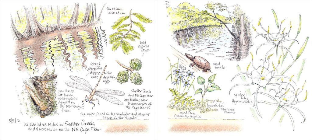
Coastal Plain: Shelter Creek Paddle Trip
5/5/12 Shelter Creek Paddle Trip
Shelter Creek flows into the NE Cape Fear and then the Cape Fear at Wilmington. I was amazed at how wide and deep the “creek” is. The tidal effect extends for 50 miles upstream! Leaching of dissolved organic matter from swamp vegetation makes the water red in sunlit shallows and black in the depths. (And see blackwater description under the Black River trip.) The stars of the show were the clumps of gorgeous spider lilies.
In addition to thanking my talented teachers in both the Botanical Illustration and Native Plant Studies programs and my advisor, Steph Jeffries, I want to thank hike leaders such as Jesse Perry and Jerry Reynolds of the N.C. Museum of Natural Sciences and Larry Mellichamp of the N.C. Native Plant Society, as well as many others, who have so generously shared their enthusiasm and information about these beautiful and precious ecological communities. Above all I want to express gratitude to my husband, David Chaika, for sharing these adventures with me and for all the time and effort he has put into the scanning, PowerPoint making, and computer support, without which these drawings would remain hidden in a little 7×8 inch sketchbook. Thank goodness there are countless gorgeous North Carolina natural gardens still to see and draw! I plan to continue this drawing project indefinitely and hope in future to publish it in some form.
Footnotes
D. Blevins and M.P. Schafale, p.81.
- R.F. Noss, p.216-217.
- Roe, p.43.
- Roe, p.62.
- Blevins and Schafale, p.111.
Bibliography
Blevins, David & Schafale, Michael P. 2011. Wild North Carolina: Discovering the Wonders of Our State’s Natural Communities. Chapel Hill: The University of North Carolina Press.
Early, Lawrence S. “Rocks Where Time Stands Still.” Wildlife in North Carolina. N.C.Wildlife Resources Commission. 8-13.
Noss, Reed F. 2013. Forgotten Grasslands of the South: Natural History and Conservation. Washington, D.C.: Island Press.
Roe, Charles E. 1987. A Directory to North Carolina’s Natural Areas. N.C. Natural Heritage Foundation.
Spira, Timothy P. 2011. Wildflowers & Plant Communities of the Southern Appalachian Mountains & Piedmont. Chapel Hill: The University of North Carolina Press.
____. 2002. North Carolina Afield: A Guide to Nature Conservancy Projects in North Carolina. Durham, NC: The Nature Conservancy.
Wells, B.W. 2002 (Revised Edition). The Natural Gardens of North Carolina. Chapel Hill: The University of North Carolina Press.
How To Visit These North Carolina Sites (and many others!)
General Accessibility:
Fieldtrips with the North Carolina Museum of Natural Sciences: www.naturalsciences.org
Fieldtrips with the North Carolina Native Plant Society: http://www.ncwildflower.org
There are also regional chapters that offer fieldtrips as well.
Fieldtips and classes in Native Plant Studies and Botanical Illustration with the North Carolina Botanical Garden: http://ncbg.unc.edu/classes-workshops
Fieldtrips with the North Carolina Nature Conservancy: http://www.nature.org/ourinitiatives/regions/northamerica/unitedstates/northcarolina/events/index.htm
Specific Sites:
The Little River Waterfalls and Cedar Rock Mountain Granite Dome are in Dupont State Forest, near Brevard, NC, and hiking trails can be accessed: http://www.dupontforest.com/
Moses Cone Park is off the Blue Ridge Parkway near Blowing Rock: www.blueridgeparkway.org
Amphibolite Mountains are publicly accessible at Elk Knob State Park and Mount Jefferson State Park: www.ncparks.gov They are near Boone, NC.
Haw River State Natural Area, off 64 near Pittsboro, is publically accessible: www.ncparks.gov
Raven Rock State Park, south of Sanford, is also publically accessible: www.ncparks.gov
Swift Creek Bluffs is a Triangle Land Conservancy preserve in Cary: http://www.triangleland.org/what-we-do/nature-preserves/swift-creek-bluffs
B.W. Wells’ Rockcliff Farm is not publically accessible, but tours can be arranged at: http://www.bwwells.org
Flower Hill Rhododendron Bluffs is a Triangle Land Conservancy preserve in north east Johnston County open to the public: http://www.triangleland.org/what-we-do/nature-preserves/flower-hill-nature-preserve
Picture Creek Diabase Glade, near Butner, is best accessed through a NCMNS fieldtrip, usually in June.
Holly Shelter Gameland, near Burgaw, and Shaken Creek Savanna, near Maple Hill in Pender County, are only accessible through an NCMNS fieldtrip or through a TNC fieldtrip: www.nature.org/northcarolina
Croatan National Forest – Island Creek Trail: Directions: Take US 70 south of New Bern and turn at the Burger King by Trent East Crossing Shopping Center. Go to the stop sign and take a left onto SR1004 and continue 7.5 miles. The trailhead is on the right.
Black River and Shaken Creek Paddletrips: through NCMNS fieldtrips or canoe outfitters.
Mitchell Mill Flatrock State Natural Area, in Wake Co., is publicly accessible: http://www.ncparks.gov
Leave a Reply